I’m a huge advocator of recce-ing courses ahead of races if possible (and not just because of my shocking navigational skills!) because I think being able to visualise a course ahead of the race really helps with race planning and on race day. It also helps if it means your recce means a visit to one of your favourite places in the world, so we were basically using our CCC recce as an excuse for an ‘active holiday’.
Logistic-wise, it’s really straightforward to do this over a long weekend. We took the evening Easyjet flight to Geneva, then had a Mountain Drop-Offs transfer to Chamonix, where we stayed one night in a hotel, and then got the first bus at 8.30am on Friday morning over the border to Courmayeur in Italy where the CCC starts – this costs 15 euros and takes about 40 minutes.
Our plan was to split the route up into three approximately 20 mile days of running, stopping at refuges in La Peule and Trient. This meant we had to carry everything we needed for the three days. Kit-wise I used my Ultimate Direction 15l Fastpack and mirrored a lot of what is mandatory CCC kit:
- waterproof jacket
- gloves
- base layer and leggings (I didn’t need these for running but changed into them when we arrived at the refuge)
- passport
- mobile phone
- 3 x 500ml bottles (two as per mandatory kit and an extra one)
In addition to this I took:
- change of clothes for each day (you could do without this if you don’t mind being a bit smelly but I figured if you can’t bring a different running skirt to wear each day of a CCC recce then when can you?!)
- basic toiletries
- Mountain King poles
- flip-flops (for the refuges)
- snacks – Mountain Fuel, Zipvit bars, GU waffles and Clif blocks (you can get breakfast and evening meal in the refuges and there are places to buy additional food/drinks enroute)
- portable charger (although you could charge at refuges)
- travel towel
- arm warmers (didn’t need these as the weather was perfect)
- sleeping bag liner (used this in La Peule but not in Trient)
I didn’t weigh my pack but it felt under 5kg and wasn’t heavy at all whilst running.
Day 1 – Courmayeur – La Peule
The CCC route is categorised by five long steep climbs, and the first essentially starts as soon as you cross the start line in Courmayeur as you ascend uphill leaving the town and head onto the first mountain – at least this means there’s no danger of going off too fast on race day!

I’d heard a lot of horror stories about how bad the CCC climbs are….and yes they are long and steep, however we’ve done a lot of high altitude trekking in the past, so compared to a lot of those trips, this climb didn’t feel ‘that’ hard. This (like with the four subsequent climbs) is simply a case of getting your head down, using your poles and maintaining a strong hiking pace.

It’s worth noting here that somehow (despite having the gpx file on my watch, a map and route description and following the TMB signs (the CCC route mainly follows the TMB hiking route but not all the time)), we made the elementary error of following two other runners who were running the CCC route and looked like they knew where they were going, and took a shortcut up to the Bertone refuge (the first aid station on race day), missing the final bit of ascent and descent. We did contemplate retracing our steps and doing the full route but knew we had a lot of running ahead of us and it would be impossible to make the same mistake on race day with nearly 2,000 other runners for company!
After Bertone, the thing that surprised me was how runnable the next section was (and there are quite a few sections like this) – I’d never really been that bothered about running the CCC before (and had only entered this year because Tom wanted to run it) as I like to run too much and didn’t think the nature of the CCC course would appeal to me, but there are plenty of sections to really get your running legs on.

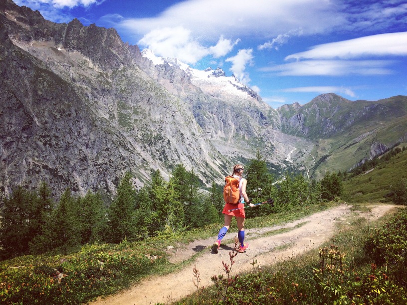
After a short climb to Bonatti refuge (where the second aid station will be) there’s another really runnable section before hitting the second of the long climbs, this time up to the Grand Col Ferret. Again I didn’t find this climb too hard, the hardest part about this one will be if it’s really hot on race day as I’d expect to be there in the afternoon and you’re completely exposed in the sunshine with no tree cover. We carried 3 x 500ml bottles each of water, filling up at fountains and stopping to buy water a couple of times, and the recce made me realise that it will be worth the extra weight of carrying an extra bottle on race day, as although aid stations are fairly frequent, plus there’s extra places to fill-up….a mile in the mountains is so much slower than a mile elsewhere and the last thing you want is to run out of water.

The descent down from the Col Ferret into Switzerland is fast and runnable and it was here we stayed overnight in La Peule, a refuge nestled into the side of the mountain with gorgeous views.
Compared to mountain huts I’ve stayed in in some parts of the world, the refuges in the Alps are positively luxurious – comfy dormitory rooms, a hot shower, a cold beer and more cheese than even I could eat (when in Switzerland and all that!).
Day 2 – La Peule – Trient
Leaving La Peule you don’t follow the TMB hiking route, but descend down a lesser used trail – apart from being quite narrow in places this was again fast and runnable. The only thing that would make this difficult was if it rained on race day.

I loved the whole of this section into Champex, and again it surprised me how runnable large parts of the course are. Terrain-wise it was also quite different to the first part; day one had been much more open with vast mountains at the side of us, today had a much more alpine forest feel to it, and we also ran through some absolutely picture perfect Swiss villages, before arriving in Champex – a gorgeous little Swiss town which marks the just past half way point of the race.

Up until now our navigation had been spot-on this second day, but there were a few scratch our head moments leaving Champex as our gpx route was telling us we were off-course and didn’t seem to tally with the route map we were following….after a bit of to-ing and fro-ing we realised our error, and needed to leave Champex and then head back onto the mountain trails.
Until we started the climb up Bovine I’d found all this section pretty easy, so this will hopefully mean a strong middle section on race day.
The climb up and past Bovine wasn’t as long as the two previous climbs but was a bit trickier underfoot in places, and similarly the descent, whilst runnable in places, did include some difficult more technical sections. My coach has me working on my descending a lot, but I still lack confidence on the really technical descents where it’s so steep you need to use your poles to keep you upright, so I do turn into a bit of a teetering fairy at times, and I know this will be my main weakness on race day.
The end of day two saw us reach Trient, where we were staying in the Auberge de Mont Blanc, where again we followed a similar pattern of hot shower, beer and lots of cheese!
Day 3 – Trient – Chamonix
Our final day (and the final 20ish miles of the race) is characterised by two long ascents/descents, the first of which is immediately after leaving Trient. This is the steepest ascent of the race (you know when you check your Strava route afterwards and you’ve ascended more than 1,100 feet a mile, it’s quite a steep climb!), however underfoot there was nothing particular difficult about it.
Apart from our little shortcut on day one and a couple of scratch our head moments on day two, we hadn’t gone off track….however when we started descending from Catogne, we read a sign wrong and ended up descending merrily down a gorgeous steep runnable section saying how wonderful this descent was going to be on race day. It was only when we got to the bottom that we realised from my watch that we’d gone VERY off-course….cue a very long hike back up the hill!

The ‘real’ descent, whilst not as fast and runnable as our ‘fake’ descent still involved some good running sections down to the village of Vallorcine, and then it’s a steady gradual climb out of the village.
With four climbs done, we knew there was just the one remaining…..and it’s safe to say the UTMB organisers save the best for last!
The final climb up to Tete aux Vents is the second longest (after the first climb out of Courmayeur), however with 50+ miles in our legs on race day, plus the terrain underfoot, this is going to be by far the most difficult section for me.
The ascent involves the most technical terrain of the race and some clambering over rock faces at times – we both remarked how it felt very similar to when we climbed Mount Kinabalu in Borneo.

There’s also no reprieve when you get to the top as the descent is rocky and very technical in places. I am under no illusion that this is going to be a slow descent into Chamonix!

After reaching the cable car at Flegere, we knew this final downhill into Chamonix from previous trips here and running in the valley, so we were looking forward to some strong running to the finish. However at this point the weather turned (up until now we had been blessed with clear, sunny but not too hot days) and the rain well and truly came down. On one hand it meant I could finally get some use out of my waterproof jacket that I’d carried through three countries, but in all serious it demonstrated that if the weather is wet on race day, it’s going to be a very different (and much harder) experience than our recce. The rain meant slippy tree roots and mud and a much slower descent than we planned, until we hit tarmac outside Chamonix.
I’d wanted to recreate the full CCC experience so we followed the route to the very end, getting a few bemused looks from Sunday afternoon shoppers as two sweaty and bedraggled runners ran through the centre of Chamonix before taking an obligatory photo where the finish line is going to be on race day.

The three day recce was useful on so many levels – firstly, whilst I know 60+ miles in the mountains is a long way for thing to go wrong on race day, it’s definitely given me the confidence that I can complete the race and hopefully in a respectable time. There was nothing that gave me any real cause for concern – I know the last climb and descent is going to be tough, but I’m just going to tell myself it’s nowhere near as bad as the UTMB runners who will have to do it with 90+ miles in their legs!
The recce also gave me the chance to use some of the kit I’ll be using in the race. I’d already decided I would be wearing my La Sportiva Akasha as they are my go-to mountain running shoe as they are light but give me plenty of cushioning and protection for the mountainous terrain, and my feet were as good as new afterwards.
It was also the perfect opportunity to really test out my poles (I’ve used them in training in Wales but I’ve only ever used them in one race before and that was a multi-day race in the Andes mountains in Ecuador, and the nature of that course meant I only needed my poles at certain times so I’d put them away when I wasn’t using them). Racing in the Alps is a completely different ballgame and unless you’re a complete mountain goat you will need to use poles throughout. I used mine on all the ascents and some of the trickier descents, and my Mountain King Trailblazer poles were absolutely perfect. There are superior poles on the market but I don’t do enough mountain running to really justify them, so for a mid-priced pole I can’t recommend the Mountain King’s enough.
Probably the most pleasing part of the three days of running is that despite covering 60+ miles/20,000 feet of ascent, my legs felt absolutely fine at the end of it so I feel like my training to date has been spot-on and is absolutely on track with three final peak 14,000+ feet of ascent training weeks to go.
The start line at 9am on 1st September in Courmayeur can’t come round soon enough now!